MANILA, Philippines – Typhoon ‘Egay’ (international name: Doksuri) continues to weaken over the Luzon Strait west of Batanes, state weather bureau PAGASA announced in its 5:00 am bulletin on Tuesday, July 27, 2023.
 |
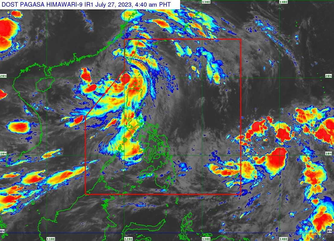
| Satellite image of ‘Bagyong Egay’ as of 4:40 am, July 27, 2023. Photo courtesy of DOST-PAGASA |
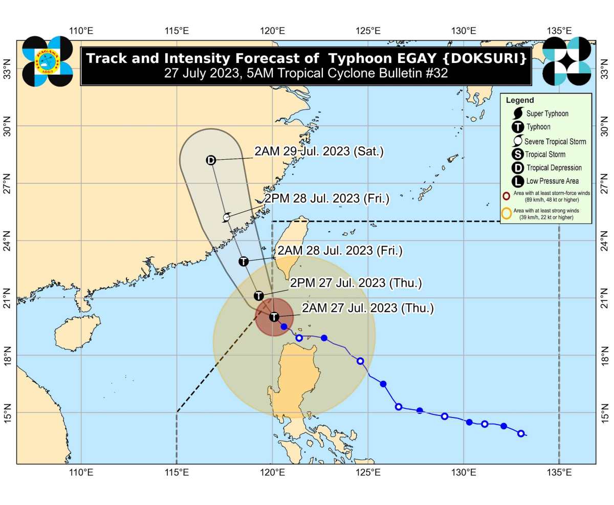
At 4:00 am today, the center of the eye of Typhoon ‘Egay’ was estimated based on all available data at 195 km West of Basco, Batanes.
‘Egay’ has maximum sustained winds of 150 km/h near the center, gustiness of up to 185 km/h, and central pressure of 955 hPa. It is moving Northwestward at 15 km/h.
Strong to typhoon-force winds extend outwards up to 630 km from the center.
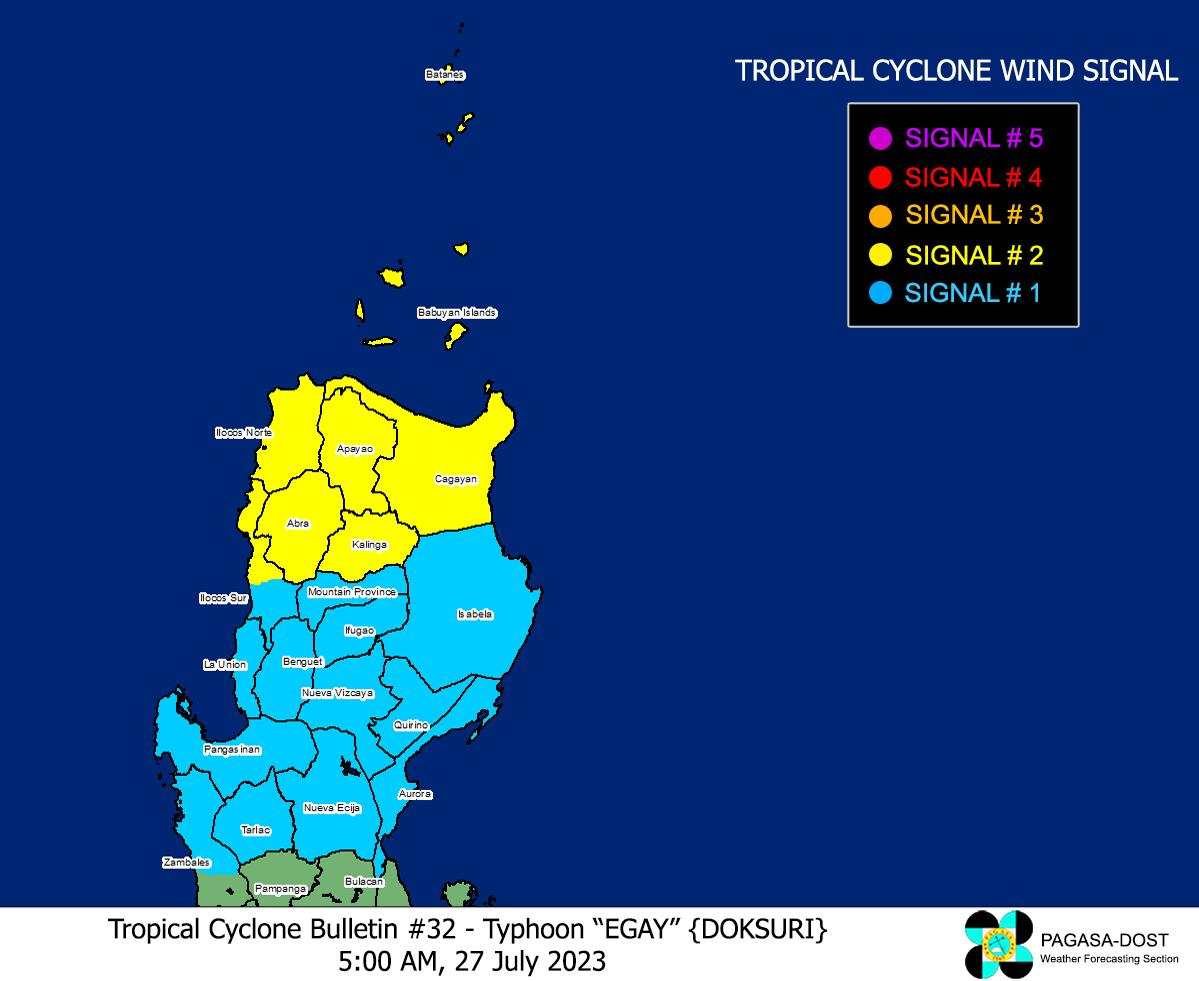
TROPICAL CYCLONE WIND SIGNALS (TCWS) IN EFFECT
TCWS No.2
- Wind threat: Gale-force winds
- Warning lead time: 24 hours
- Range of wind speeds: 62 to 88 km/h (Beaufort 8 to 9)
- Potential impacts of winds: Minor to moderate threat to life and property
LUZON
- Batanes
- Cagayan including Babuyan Islands
- Apayao
- Kalinga
- Abra
- Ilocos Norte
- the northern and central portion of Ilocos Sur (Magsingal, San Esteban, Banayoyo, Burgos, City of Candon, Santiago, San Vicente, Santa Catalina, Lidlidda, Nagbukel, Sinait, San Ildefonso, Galimuyod, City of Vigan, San Emilio, Cabugao, Caoayan, San Juan, Santa, Bantay, Santo Domingo, Santa Maria, Narvacan)
TCWS No.1
- Wind threat: Strong winds
- Warning lead time: 36 hours
- Range of wind speeds: 39 to 61 km/h (Beaufort 6 to 7)
- Potential impacts of winds: Minimal to minor threat to life and property
LUZON
- Isabela
- Quirino
- Nueva Vizcaya
- Mountain Province
- Ifugao
- Benguet
- the rest of Ilocos Sur
- La Union
- Pangasinan
- Aurora
- Nueva Ecija
- Tarlac
- the northern portion of Zambales (Botolan, Iba, Candelaria, Cabangan, Palauig, Santa Cruz, Masinloc)

TRACK AND INTENSITY OUTLOOK
Typhoon ‘Egay’ is forecast to track northwestward or north northwestward over the Luzon Strait, the sea southwest of Taiwan, and the Taiwan Strait throughout the forecast period while gradually accelerating.
The typhoon may exit the Philippine Area of Responsibility (PAR) this morning or afternoon. It is also forecast to make landfall in the vicinity of Fujian, China tomorrow morning.

The disturbance is forecast to slightly weaken prior to its landfall over China. Rapid weakening is expected once ‘Egay’ makes landfall over mainland China and moves further inland.
HAZARDS AFFECTING LAND AREAS
The Southwest Monsoon enhanced by ‘Egay’ will continue to bring occasional to monsoon rains over the western portions of Central Luzon and Southern Luzon in the next three days.
The enhanced Southwest Monsoon will continue to bring gusty conditions over the following areas not under any Wind Signal, especially in coastal and upland/mountainous areas exposed to winds:
- Today: Luzon and Western Visayas
- Tomorrow: Batanes, Ilocos Region, Zambales, Bataan, Cavite, the southern portion of Quezon, MIMAROPA, Bicol Region, and Western Visayas
- Saturday: Zambales, Bataan, Cavite, Romblon, the northwestern portion of Antique, and Kalayaan Islands.
There is a moderate to high risk of storm surge which may cause flooding in the low-lying and exposed coastal areas of Batanes, the northwestern portion of Cagayan including Babuyan Islands, Ilocos Norte, and extreme northern portion of Ilocos Sur. Maximum surge heights may reach 3.0 m some of the warning areas.
HAZARDS AFFECTING COASTAL WATERS
Under the influence of ‘Egay’ and the enhanced Southwest Monsoon, a Gale Warning is in effect over several coastal waters along the seaboards of Luzon and the eastern and western seaboards of Visayas.
Rough to high or very high seas: Sea travel is risky for most vessels. All mariners are advised to remain in port or seek safe harbor until winds and waves subside.
Rough to very rough seas: Sea travel is risky for small seacrafts. For larger vessels, operating in gale conditions requires experience and properly equipped vessels. Mariners without proper experience or operating ill-equipped vessels are advised to remain in port or seek safe harbor.
TROPICAL CYCLONES
‘Bagyong Egay’ is the fifth tropical cyclone for 2023. It originated from an area of low-pressure east of southeastern Luzon that developed into a tropical depression on Friday, July 21.
SEE ALSO: LIST: Typhoon, tropical cyclone names in the Philippines 2023
On average, there are 20 tropical cyclones that could form or enter the PAR each year. Only half of those are projected to make landfall.
— The Summit Express


