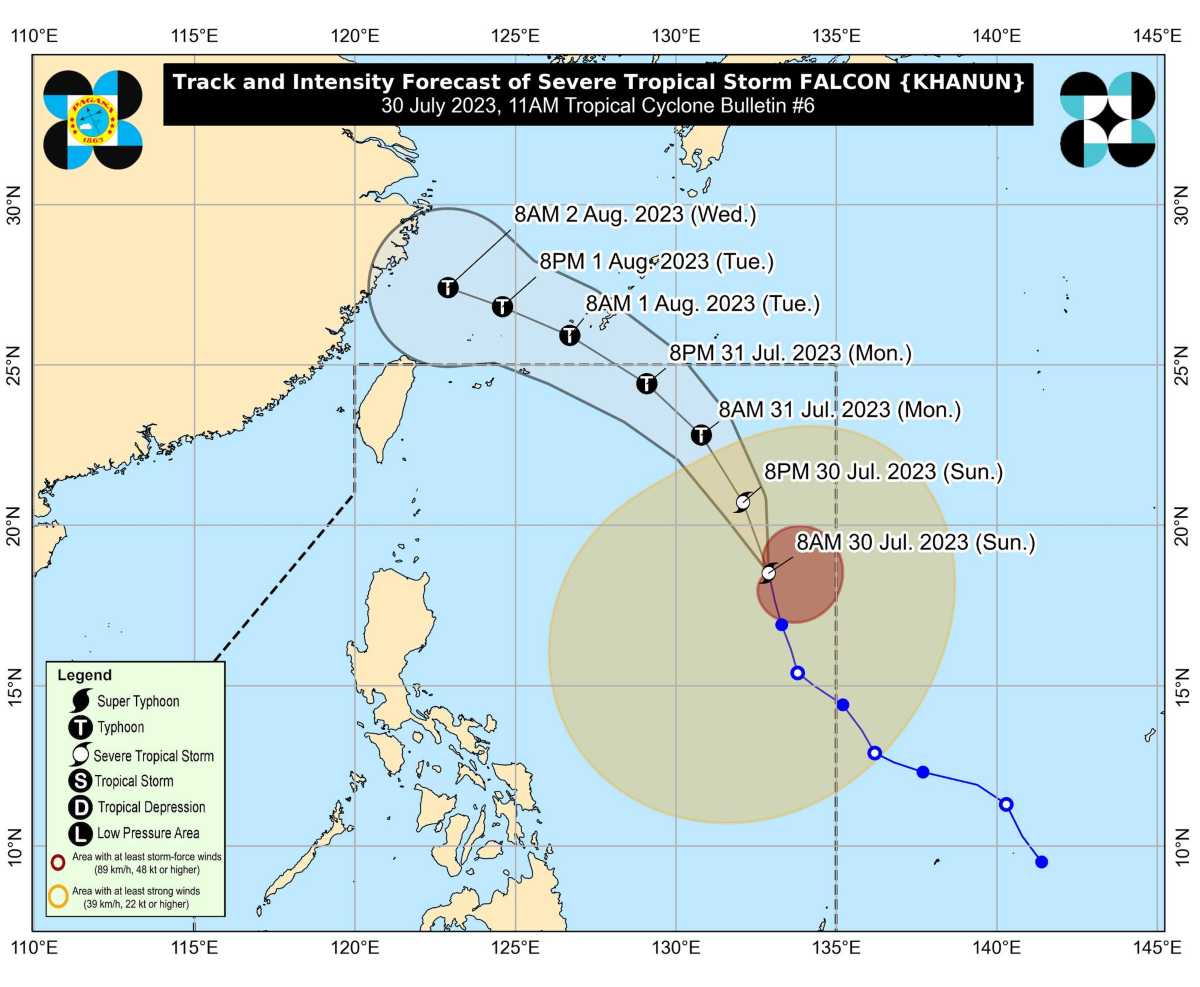
The center of ‘Bagyong Falcon’ was estimated based on all available data at 1,180 km East of Northern Luzon.
 |
| Satellite image of ‘Bagyong Falcon’ as of 10:40 am, July 30, 2023. Photo courtesy of DOST-PAGASA |
‘Falcon’ has maximum sustained winds of 95 km/h near the center, gustiness of up to 115 km/h, and central pressure of 985 hPa. It is moving north northwestward at 15 km/h.
Strong to storm-force winds extend outwards up to 900 km from the center.
TROPICAL CYCLONE WIND SIGNALS (TCWS) IN EFFECT
No Wind Signal hoisted at this time.
TRACK AND INTENSITY OUTLOOK
Over the Philippine Sea, ‘Falcon’ is forecast to move north northwestward today, then turn northwestward tomorrow.
On the track forecast, the tropical storm may exit the Philippine Area of Responsibility (PAR) tomorrow evening or on Tuesday early morning.
Outside the PAR region, FALCON will turn west northwestward and pass close to Okinawa Islands in the Ryukyu Archipelago on Tuesday morning before entering the East China Sea.

‘Falcon’ is forecast to steadily intensify within the next 3 days. It is forecast to become a typhoon between late evening today or tomorrow early morning and reach its peak intensity on Tuesday.
HAZARDS AFFECTING LAND AREAS
Heavy Rainfall Outlook
The Southwest Monsoon enhanced by Severe Tropical Storm ‘Falcon’ will bring occasional to monsoon rains over the western portions of Luzon and Visayas in the next three days.
The hoisting of Wind Signal due to ‘Falcon’ over any locality in the country remains unlikely based on the current forecast scenario. However, the enhanced Southwest Monsoon will bring gusty conditions over the following areas, especially in coastal and upland/mountainous areas exposed to winds:
Today: Zambales, Bataan, Pampanga, Bulacan, Metro Manila, Occidental Mindoro, Palawan, Romblon, Northern Samar, and most of CALABARZON, Bicol Region and Western Visayas.
Tomorrow (July 31): Ilocos Norte, Pangasinan, Zambales, Bataan, Pampanga, Bulacan, Metro Manila, Occidental Mindoro, Palawan, Romblon, Northern Samar, and most of CALABARZON, Bicol Region and Western Visayas.
Tuesday (August 1): Ilocos Region, Abra, Benguet, Zambales, Bataan, Bulacan, Metro Manila, Bicol Region, and most of CALABARZON, MIMAROPA, and Western Visayas
HAZARDS AFFECTING COASTAL WATERS
Under the influence of the enhanced Southwest Monsoon, a Gale Warning is in effect over several coastal waters along the western seaboard of Luzon.
Sea travel is risky for small seacrafts. For larger vessels, operating in gale conditions requires experience and properly equipped vessels. Mariners without proper experience or operating ill-equipped vessels are advised to remain in port or seek safe harbor.
TROPICAL CYCLONES
‘Bagyong Falcon’ is the sixth tropical cyclone for 2023. It entered PAR on Saturday.
SEE ALSO: LIST: Typhoon, tropical cyclone names in the Philippines 2023
On average, there are 20 tropical cyclones that could form or enter the PAR each year. Only half of those are projected to make landfall.
— The Summit Express

