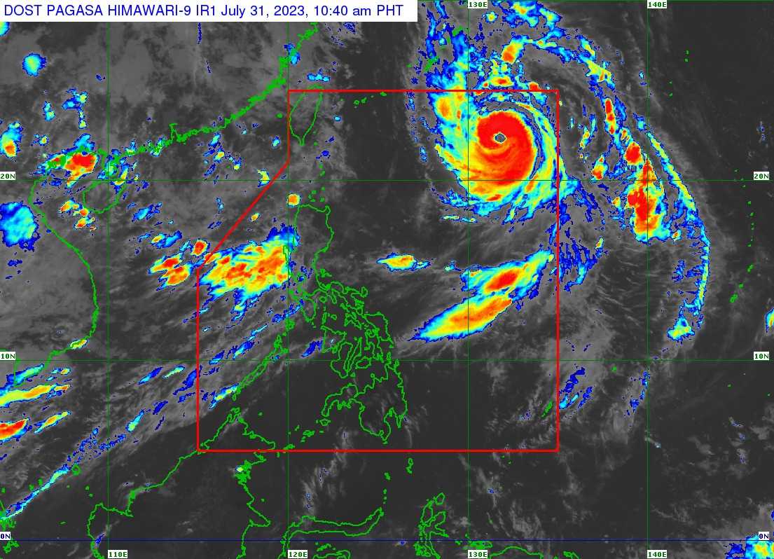
The center of the eye of Typhoon ‘Falcon’ was estimated based on all available data at 1,045 km East of Extreme Northern Luzon.
 |
| Satellite image of ‘Bagyong Falcon’ as of 10:40 am, July 31, 2023. Photo courtesy of DOST-PAGASA |
‘Falcon’ has maximum sustained winds of 150 km/h near the center, gustiness of up to 185 km/h, and central pressure of 950 hPa. It is moving north northwestward at 15 km/h.
Strong to typhoon-force winds extend outwards up to 750 km from the center.
TROPICAL CYCLONE WIND SIGNALS (TCWS) IN EFFECT
No Wind Signal hoisted at this time.
TRACK AND INTENSITY OUTLOOK
Over the Philippine Sea, ‘Falcon’ is forecast to slightly accelerate north northwestward or northwestward in the next 24 hours then turn west northwestward tomorrow afternoon.
On the track forecast, the typhoon may exit the Philippine Area of Responsibility (PAR) between tomorrow afternoon and tomorrow evening.
Outside the PAR region, ‘Falcon’ will turn west northwestward and pass close (landfall not ruled out) over Okinawa Islands in the Ryukyu Archipelago between tomorrow evening and Wednesday morning while gradually decelerating.

It is forecast to further intensify over the next 1 or 2 days and may reach its peak intensity tomorrow or on Wednesday.
HAZARDS AFFECTING LAND AREAS
Heavy Rainfall Outlook
The Southwest Monsoon (Habagat) enhanced by Typhoon ‘Falcon’ will bring occasional to monsoon rains over the western portion of Luzon and Visayas in the next three days.
The hoisting of Wind Signal due to ‘Falcon’ over any locality in the country remains unlikely based on the current forecast scenario. However, the enhanced Southwest Monsoon will bring gusty conditions over the following areas, especially in coastal and upland/mountainous areas exposed to winds:
Today: Zambales, Bataan, the central and southern portions of Aurora, Pampanga, Bulacan, Metro Manila, and most of Ilocos Region, CALABARZON, MIMAROPA, Bicol Region, and Western Visayas
Tomorrow (August 1): Batanes, Babuyan Islands, Abra, Benguet, Zambales, Bataan, the central and southern portions of Aurora, Pampanga, Bulacan, Metro Manila, and most of Ilocos Region, CALABARZON, MIMAROPA, Bicol Region, and Western Visayas
Wednesday (August 2): Batanes, Babuyan Islands, Ilocos Region, Abra, Benguet, Aurora, Zambales, Bataan, Bulacan, Pampanga, Metro Manila, CALABARZON, MIMAROPA, Bicol Region, the western portion of Northern Samar, and most of Western Visayas
HAZARDS AFFECTING COASTAL WATERS
In the next 24 hours, the Southwest Monsoon enhanced by ‘Falcon’ will bring moderate to rough seas over the coastal waters along the northern (1.2 to 2.8 m), western (2.5 to 3.5 m) and southern (1.5 to 3.0 m) seaboards of Luzon.
Mariners of small seacrafts are advised to take precautionary measures when venturing over these waters. If inexperienced or operating ill-equipped vessels, avoid navigating in these conditions.
TROPICAL CYCLONES
‘Bagyong Falcon’ is the sixth tropical cyclone for 2023. It entered PAR on Saturday.
SEE ALSO: LIST: Typhoon, tropical cyclone names in the Philippines 2023
On average, there are 20 tropical cyclones that could form or enter the PAR each year. Only half of those are projected to make landfall.
— The Summit Express


