MANILA, Philippines – Typhoon ‘Egay’ (international name: Doksuri) wobbles over the waters near Fuga Island in Babuyan Islands, state weather bureau PAGASA announced in its 8:00 am bulletin on Wednesday, July 26, 2023.
 |
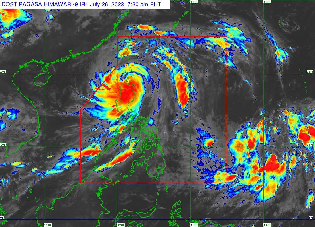
| Satellite image of ‘Bagyong Egay’ as of 7:30 am, July 26, 2023. Photo courtesy of DOST-PAGASA |
At 7:00 am today, the center of the eye of Typhoon ‘Egay’ was estimated based on all available data over the coastal waters of Aparri (Fuga Is.), Cagayan.
Typhoon ‘Egay’ has maximum sustained winds of 175 km/h near the center, gustiness of up to 240 km/h, and central pressure of 935 hPa. It is moving west southwestward at 15 km/h.
Strong to typhoon-force winds extend outwards up to 700 km from the center.
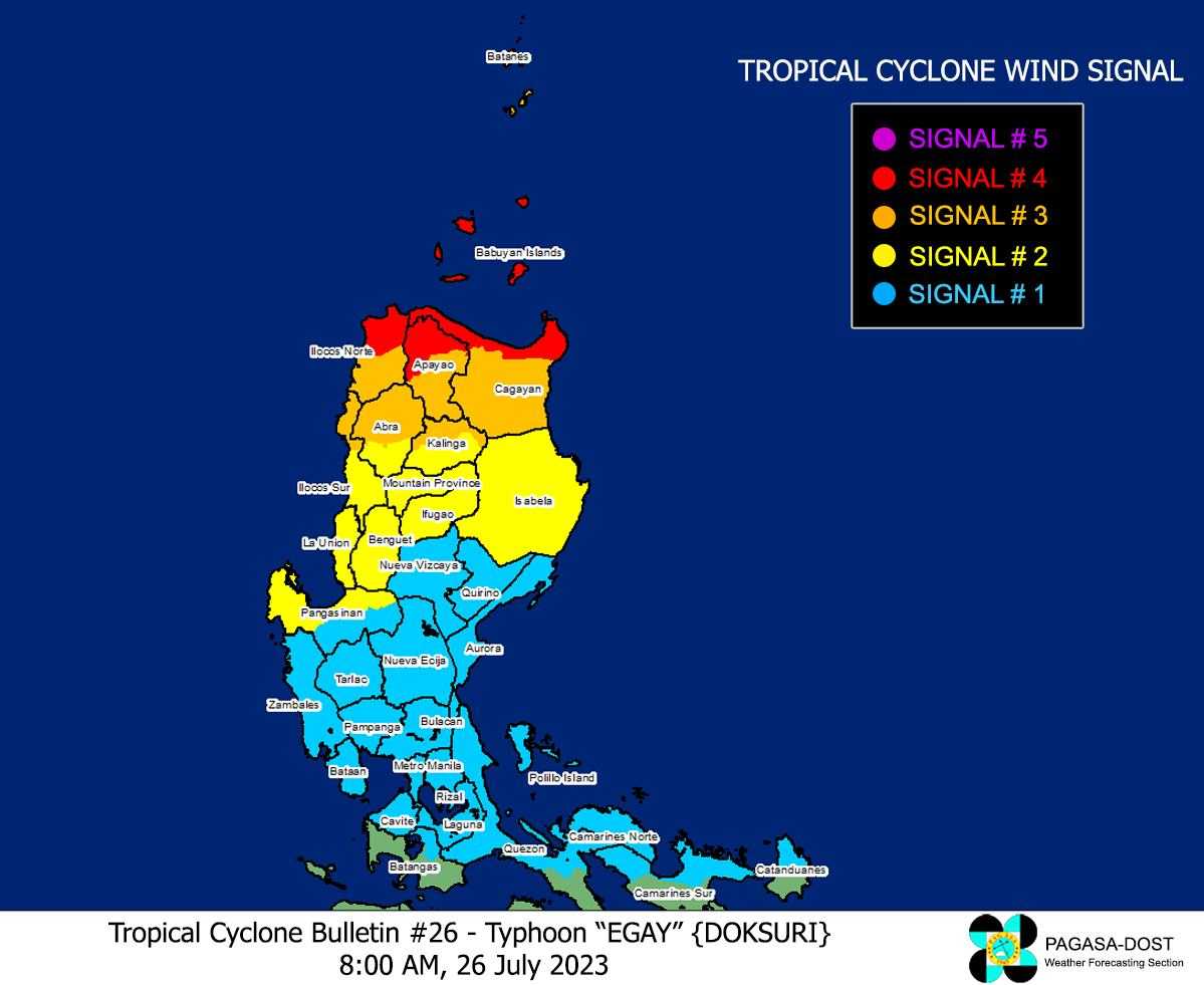
TROPICAL CYCLONE WIND SIGNALS (TCWS) IN EFFECT
TCWS No. 4
- Wind threat: Typhoon-force winds
- Warning lead time: 12 hours
- Range of wind speeds: 118 to 184 km/h (Beaufort 12)
- Potential impacts of winds: Significant to severe threat to life and property
Luzon
- the northern portion of Cagayan (Santa Ana, Gonzaga, Claveria, Sanchez-Mira, Pamplona, Abulug, Ballesteros, Aparri, Buguey, Santa Teresita, Camalaniugan, Santa Praxedes) including Babuyan Islands
- the northern portion of Apayao (Calanasan, Luna, Santa Marcela)
- the northern portion of Ilocos Norte (Burgos, Bangui, Dumalneg, Pagudpud, Adams, Pasuquin, Vintar, Bacarra)
TCWS No. 3
- Wind threat: Storm-force winds
- Warning lead time: 18 hours
- Range of wind speeds: 89 to 117 km/h (Beaufort 10 to 11)
- Potential impacts of winds: Moderate to significant threat to life and property
Luzon
- Batanes
- the rest of Cagayan
- the rest of Apayao
- the northern portion of Kalinga (Rizal, Pinukpuk, Balbalan)
- the northern portion of Abra (Tineg, Lagayan, Lacub, Danglas, Bangued, La Paz, San Juan, Dolores, Tayum, Lagangilang, Malibcong, Licuan-Baay, Peñarrubia, Pidigan, Langiden, San Quintin, Bucay, San Isidro, Sallapadan)
- the rest of Ilocos Norte
- the northern portion of Ilocos Sur (Magsingal, San Juan, Cabugao, Sinait, San Vicente, Santo Domingo, San Ildefonso, Bantay, Santa Catalina, City of Vigan, Caoayan, Santa, Nagbukel, Narvacan)
TCWS No. 2
- Wind threat: Gale-force winds
- Warning lead time: 24 hours
- Range of wind speeds: 62 to 88 km/h (Beaufort 8 to 9)
- Potential impacts of winds: Minor to moderate threat to life and property
Luzon
- Isabela
- the rest of Kalinga
- Mountain Province
- Ifugao
- Benguet
- the rest of Abra
- the rest of Ilocos Sur
- La Union
- the northern and western portions of Pangasinan (Sison, San Jacinto, Pozorrubio, San Fabian, Dagupan City, Calasiao, Binmaley, Lingayen, Bugallon, Mabini, Labrador, Infanta, Dasol, Burgos, Agno, City of Alaminos, Sual, Anda, Bolinao, Bani, San Manuel, Binalonan, Laoac, Manaoag, Mangaldan, Mapandan, Santa Barbara, San Nicolas)
TCWS No. 1
- Wind threat: Strong winds
- Warning lead time: 36 hours
- Range of wind speeds: 39 to 61 km/h (Beaufort 6 to 7)
- Potential impacts of winds: Minimal to minor threat to life and property
Luzon
- Aurora
- Quirino
- Nueva Vizcaya
- the rest of Pangasinan
- Nueva Ecija
- Tarlac
- Pampanga
- Bulacan
- Zambales
- Bataan
- Metro Manila
- Rizal
- Cavite
- Laguna
- the northern portion of Batangas (Talisay, City of Tanauan, Santo Tomas, Balete, Malvar, Lipa City)
- the northern and central portion of Quezon (Pitogo, Calauag, Infanta, Lopez, Guinayangan, Unisan, Plaridel, Quezon, Alabat, Padre Burgos, Mauban, General Nakar, Perez, Agdangan, Gumaca, Atimonan, Real, Tagkawayan, Lucena City, Pagbilao, Lucban, Sampaloc, City of Tayabas, Dolores, Sariaya, Candelaria, Tiaong, San Antonio) including Polillo Islands
- Camarines Norte
- the northern portion of Camarines Sur (Siruma, Tinambac, Goa, Lagonoy, Caramoan, Cabusao, Sipocot, Garchitorena, Ragay, Del Gallego, Calabanga, Presentacion, Lupi)
- the northern portion of Catanduanes (Pandan, Bagamanoc, Panganiban, Viga, Caramoran)

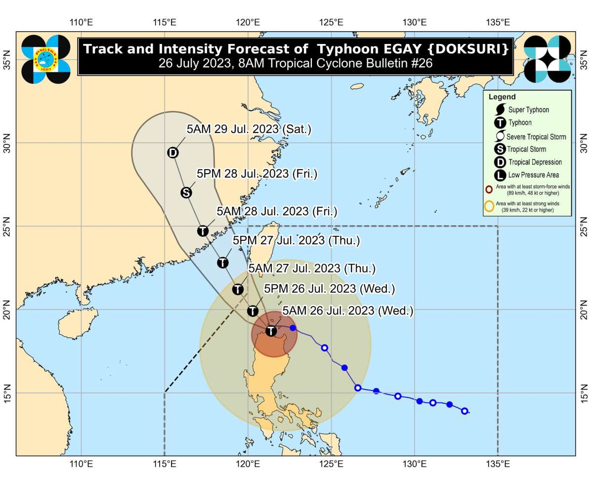
TRACK AND INTENSITY OUTLOOK
In the next 6 hours, ‘Egay’ may exhibit trochoidal or wobbling motion while in the vicinity of the Babuyan Islands. As such, a landfall over northwestern Cagayan is not ruled out.
Afterwards, ‘Egay’ will turn generally northwestward or north northwestward and pass over the waters south and southwest of Taiwan.
It is forecast to exit the Philippine Area of Responsibility tomorrow morning.
Outside the PAR region, ‘Egay’ will cross the Taiwan Strait and make landfall in the vicinity of Fujian, China on Friday morning.

‘Egay’ is forecast to weaken throughout the forecast period, although the rate of weakening will not be rapid due to slightly favorable environment offsetting the impact of land interaction with the rugged terrain of Northern Luzon and Taiwan.
A more rapid weakening is expected once EGAY makes landfall and moves inland over mainland China, with the tropical cyclone degenerating into a remnant low by Saturday.
HAZARDS AFFECTING LAND AREAS
Forecast rainfall are generally higher in elevated or mountainous areas. Under these conditions, flooding and rain-induced landslides are highly likely especially in areas that are highly or very highly susceptible to these hazards as identified in hazard maps and in localities that experienced considerable amounts of rainfall for the past several days.
The Southwest Monsoon enhanced by the typhoon will continue to bring occasional to monsoon rains over the western portions of Central Luzon, Southern Luzon, and Visayas in the next three days.
Violent, life-threatening conditions are expected to continue over Babuyan Islands, the northwestern portion of mainland Cagayan, and the northern portions of Apayao and Ilocos Norte in the next 6 hours.
Significant to severe impacts from typhoon-force winds may be experienced within the areas under Wind Signal No. 4.
HAZARDS AFFECTING COASTAL WATERS
Under the influence of ‘Egay’ and the enhanced Southwest Monsoon, a Gale Warning is in effect over several coastal waters along the seaboards of Luzon and Visayas.
TROPICAL CYCLONES
‘Bagyong Egay’ is the fifth tropical cyclone for 2023. It originated from an area of low-pressure east of southeastern Luzon that developed into a tropical depression on Friday, July 21.
SEE ALSO: LIST: Typhoon, tropical cyclone names in the Philippines 2023
On average, there are 20 tropical cyclones that could form or enter the PAR each year. Only half of those are projected to make landfall.
— The Summit Express


